


Many islands appear on old maps that correspond to nothing at all. This leads modern "scholars" to dismiss everything that appears on antique maps. However some of these islands fit too neatly with existing landmasses to dismiss as myth. One of them is Antillia.
Antillia is a large, mostly rectangular island with a peninsula at the one end, with its long axis oriented North-South. It has seven prominent bays along its coast. Here is an old map of Antillia compared to a modern CIA map of Puerto Rico. It can be seen that the two islands are very similar in shape.

The Portugese were early explorers who rediscovered many islands, including the Azores in the early 15th century. Their navagation methods were not very sophisticated at the time, and they miscalculated the size of the Earth (it IS a myth that people in the Early Modern Period thought the Earth was flat. It had been known since Hellenistic times that the Earth was a sphere.). The distance from the Azores to Antillia was estimated at 1,400 kilometers, whereas the actual distance between the Azores and Puerto Rico is 4,500 kilometers, putting them off by a factor of three.
If you sail in a straight line from Portugal to Puerto Rico you would approach the island from the North East. The island, as viewed directly from Portugal, would appear to be oriented with the long axis vertical (North-South), as it appears on early maps identified as Antillia. Portugese explorers are said to have discovered (or rediscovered even, as many stories attribute the original discovery to Arab sailers 700 years prior) Antillia in the 1420s, more than 70 years before Columbus in 1493.
Columbus planned his voyages based on maps from earlier Portugese sailers. It is no coincidence he landed where he did, in the West Indies. He was headed in the direction of Antillia on those maps. Antillia was what Columbus was looking for, not India, not China, not Indonesia. It is no coincidence that Columbus arrived at Puerto Rico during his second voyage, it was intentional.
In some maps a chain of islands appear in an arc along the long axis of Antillia, to the "South". When we reorient the map these islands correspond very closely to the chain of islands known today as the Lesser Antilles. These too are real islands.
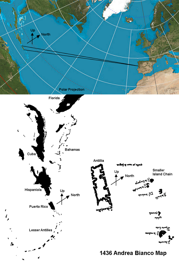
If we look at a polar projection of the Earth we can see the Caribbean as it would appear from Portugal if the Earth was flat like a map. The islands are now situated vertically. Similarly Antillia is depicted on maps as being a large, rectangular island oriented with its long axis running slightly off from vertical at roughly the same latitude as Portugal. On the polar projection we can see Puerto Rico is a largely rectangular island, with its long axis situated nearly vertically, at roughly the same latitude as Portugal.
Early maps depicting Antillia were navigational charts. They did not attempt to accurately depict the shape of the Earth as a sphere, but provided an estimate of distances and directions for ships' pilots. Early maps were far from accurate. Florida and California were both depicted as islands at first, and Ceylon was placed to the West of India, instead of the East where it really is. Accuracy of distances decreased the farther from the mainland a ship traveled. This can be seen with the position of the Azores islands, with the error in distance increasing with the farther islands. The distance to the Azores are often underestimated. The same is true with Antillia, which is placed three times closer to Europe than the Caribbean is in reality.
On some maps directly above Antillia (to the West on our reoriented polar projection) is another large island called Satanazes. Sometimes there are four islands depicted. There are four larger islands in the Caribbean (Cuba, Hispaniola, Jamaica, and Puerto Rico), along with numerous smaller ones.
The identification with Antillia and the islands surrounding it with the islands of the Caribbean is nothing new. It has been a stubborn hypothesis from the very beginning of the age of exploration. On his 1492 globe German mariner and geographer Martin Behaim placed Antilia along the Tropic of Cancer, just slightly to the north of Cuba. Peter Martyr d'Anghiera, a Spanish historian writing in 1511, explicitly states that Columbus reached Antillia on his voyages.
Early 19th century German geographer Johann Georg Heinrich Hassel posited the same hypothesis in 1822 and late 19th early 20th century American lawyer, writer, and historian William H. Babcock was published in the peer reviewed Geographical Review detailing the Antillia in the Caribbean hypothesis. He also wrote a book about the subject, that was published the year he died.
Cuba appears to be the most popular candidate for historians and geographers. Personally, with its location and very blocky shape, I identify Antillia with Puerto Rico. It just fits. It fits a lot better than old maps of Scandinavia or China or maps that left out the Arabian peninsula entirely. The shape, position, and location of the islands of Antillia on old maps fits well with the four large islands of the Caribbean. And it is by no means impossible to suggest that the Portuguese discovered these islands 70 years prior to Columbus. The New World had already been visited by the Vikings in the year AD 1000. Hanno the Navigator explored the coast of Africa up to Cameroon in 500 BC. Pre-Columbian Atlantic travel was not only possible, it is historical fact.
Another "lost" island, seen in the picture, is Brasil, also known as Hy-Brasil. You can read more about it in the picture, and here.


No comments:
Post a Comment